SW Parks Trip – Lake Powell

Lake Powell, Arizona, USA

In November 2012, Daniele and I took a camping trip to the South-West US. We flew in and out of Las Vegas, then spent a few days at the Grand Canyon, followed by the Petrified Forest, and Monument Valley. From Monument Valley we tried to hit as many other sites as we could working our way back to Vegas, where we would catch a flighty back to New Jersey for Thanksgiving.

On the way to Lake Powell, Arizona, USA

It was a lot of driving but the roads are so open and the scenery is so different from the North-East that it was a pleasure. Our first stop was Glen Canyon Dam. We had kinda wanted to fit in a “Dam” and this one was on our way.

Daniele at Glen Canyon Dam, Arizona, USA

Glen Canyon Dam was nice. We only stayed a little bit, but there was interesting terrain to climb up on and nice views. Groups of tourists arrived in waves to take a picture and continue on their way.

Glen Canyon Dam, Arizona, USA

Our bigger stop was Lake Powell — which was very pretty. We drove right down to the beach and hung out here a little while. There were also RVs/Campers parked right on the sandy beach, which seemed like a nice place to park your RV.

Lake Powell, Arizona, USA

We didn’t quite realize how soft and loose the sand was, and we got stuck when we tried to leave. My years experience of getting a car stuck out of snow payed off, we eventually got out without a tow truck. But it was close!

Lake Powell, Arizona, USA

Our next stop was the town on Kanab, which was a nice little stop in a nice little town.

Hotel in Utah, USA
Hotel in Utah, USA

We had lunch in this cute little restaurant. They had an unlimited soup and salad bar for something like $5. There was home-made soups and a really nice salad fixings. As two hungry hikers, we really went to town on this. Also, we probably smelled and looked less than civilized (right before this we had been digging a rental car out of the sand) — but the staff were incredibly sweet. The ladies luncheon going on at the next table only passed us a few sideways glances.

Resturant in Kanab, Utah, USA

The restaurant staff told us about Best Friends Animal Santuary just on the edge of town. So we went there after lunch to check it out.

Best Friends Animal Sanctuary, Kanab, Utah, USA

We got on one of their last bus tours to the various areas of the sanctuary. My favorite was the cat house. But the bigger animals were cool to see too.

Best Friends Animal Sanctuary, Kanab, Utah, USA

The sun was setting as we were leaving Best Friends. So from there we hit the road until we were just outside Las Vegas. There we found a wide variety of hotels and motels for super cheap. We randomly picked one to sleep and shower (as a courtesy to our fellow airline passengers the next day). In the morning we bummed around Vegas for the day before catching our flight back to New Jersey.

Our view for most of our South-West Camping Road Trip

The photos from this part of our South-West Parks / Camping trip are online here:
https://plus.google.com/photos/+KaitlynHanrahanIsidori/albums/6053113319704196817

SW Parks Trip – Monument Valley

Monument Valley Navajo Tribal Park, Arizonia and Utah, USA

Our next stop on out South-West Parks trip, after flying into Las Vegas, spending a few days climbing down and up the Grand Canyon, and visiting the Petrified Forest was Monument Valley. We got there at sun rise. This picture above is the typical scenery we passed driving from park to park.

Monument Valley Navajo Tribal Park, Arizonia and Utah, USA

We crossed over from Arizona to Utah to visit Monument Valley Navajo Tribal Park. As the name implies, it’s not actually in “Utah” (though Utah and Arizona is physically where you would find it on a map) it is in the Navajo Nation.

Monument Valley Navajo Tribal Park, Arizonia and Utah, USA

We drove through most of the night to get here from the Petrified Forest. The Rangers over at the Petrified Forest had some pretty strong warnings about this plan. Firstly that the roads through the Navajo Nation are very dark and unpredictable. Also, that the farmers and people who live near the roads don’t pen in their live stock, so you might just find yourself blocked by some cows, horses, or anything. And if you accidentally hit one of these animals, then the owner sets the price, with no restrictions, on what that animal is worth and what you have to pay him. In the end we made the trip incident free, we were only stopped once or twice by a small herd of cows in the road. We also filled our tank with some really cheap gasoline!

Monument Valley Navajo Tribal Park, Arizonia and Utah, USA

Visiting Monument Valley, which is run by the Navajo Nation Parks and Recreation, gave me a new appreciation for how the parks run by the US Parks Department are so well organized. The information desk never actually opened the day we visited. There was a person who took a fee at the main entrance, who gave us a map. As well as a gift shop that made it clear that they were not an information desk.

Monument Valley Navajo Tribal Park, Arizonia and Utah, USA

During our stay we drove all the paths that you can drive (getting out at each monument to admire it) and hiked a few more. We saw the whole park with the exception of the areas that are considered too sacred for non tribe member to go walking through. I think the whole park is considered sacred, but only some areas are off limits. If you really want, a guide can bring you to some of them.

Monument Valley Navajo Tribal Park, Arizonia and Utah, USA

Each rock formation has a cool name based on what it looks like and a story that goes along with that. These are the “Three Sisters” which is a formation of a Catholic nun facing her two pupils. I don’t remember them all now, but there is a list for those who are curious.

Monument Valley Navajo Tribal Park, Arizonia and Utah, USA Monument Valley Navajo Tribal Park, Arizonia and Utah, USA Monument Valley Navajo Tribal Park, Arizonia and Utah, USA Monument Valley Navajo Tribal Park, Arizonia and Utah, USA

Director John Ford used the park for some of his movies, including Stagecoach (1939) and The Searchers (1956), as well as other Western movie directors. Critic Keith Phipps said about the area, “its five square miles have defined what decades of moviegoers think of when they imagine the American West.” Below is a picture of “John Ford’s Point” and it does indeed feel right out of a movie.

Monument Valley Navajo Tribal Park, Arizonia and Utah, USA Monument Valley Navajo Tribal Park, Arizonia and Utah, USA

Inside the Information Center there were really nice displays on the history of the local tribes. Specifically lots of information on the Navajo Code Talkers and their contributions to World War II.

Monument Valley Navajo Tribal Park, Arizonia and Utah, USA Monument Valley Navajo Tribal Park, Arizonia and Utah, USA

There were some examples of typical homes of the original natives just outside the park’s info center. They look about like I guess they would have to look like given the naturally occurring resources of the area.

Monument Valley Navajo Tribal Park, Arizonia and Utah, USA

We had planned on getting a back-country camping permit — hence the need to talk to someone who worked for the park. But there was a paper indicating that they were not giving those out at the moment due to some unspecified maintenance. In the end, the guy at the gate gave us directions to private camping grounds near by.

25-monumentvalley-0806-Edit 26-monumentvalley-0829

We found the nearby private camping grounds easily enough. It was car camping rather than our planned back-country camping, but it turned out to be one of our best nights. We had the luxury of flushing toilets along with a view of Monument Valley.

27-monumentvalley-0833

Here is our lovely camping site. Not pictured are several cats that hung around hoping for some noms. And look, our rental car made it into this picture below.

29-monumentvalley-0837

Daniele was a boyscout. He took point over the camp fire and dinner. We also had smores. This was Daniele’s very first smore! He insisted that it is something I made up. So please tell him that smores are a real thing next time you see him.

30-monumentvalley-0839

The full photo album from Monument Valley is online here:
https://plus.google.com/photos/+KaitlynHanrahanIsidori/albums/6053097484050479489

SW Parks Trip – Petrified Forest

Petrified Forest National Park, Arizona, USA

Our next stop after the Grand Canyon in out November 2012 South-West Parks Camping Trip was the Petrified Forest. Petrified Forest National Park is quite big (146 square miles) and we spent the day driving from section to section and taking hiking trails within each.

Petrified Forest National Park, Arizona, USA

We first passed through the colorful desert like Badlands part of the National Park, called the Painted Desert. This area didn’t have much of the characteristic petrified wood, but was still very striking.

Petrified Forest National Park, Arizona, USA

Historic Route 66 passes through here, which is pretty neat. This old auto body was just sitting there asking to be photographed. No idea why it was there.

Petrified Forest National Park, Arizona, USA

There are also a few specific “sites to see” within the park. Including native american ruins, hieroglyphics, and the visitor center.

Petrified Forest National Park, Arizona, USA
Painted Desert, Petrified Forest National Park, Arizona, USA

The main event is the petrified (fossilized) wood. The surplus of petrified wood in this area gives the park its name. Unfortunately they have lost a lot of the petrified wood that was once here due to visitors stealing it. Now they have more rangers to try to control stealing a little better, but it is still a huge problem. These logs are found all over the area, not just within the park, so it is hard to say if the stores just outside the park stole their wares or if they came from their own collection from their own property as advertised.

Petrified Forest National Park, Arizona, USA

Petrified Wood, which literally means “wood turned to stone”, are fossilized remains of plant life. They are unique to other fossils because they are a three-dimensional representation of the original, rather than simply an impression. But how?! First the tree ends up underground, initially preserving it because there is no oxygen for aerobic decomposition. Then mineral-laden water penetrates the plant matter cell-by-cell depositing its minerals inside and thus preserving the structure of the original living tree at a cellular level (“permineralization”). Eventually the plant matter does decay and is completely replaced by stone. The whole process is called petrifaction and gives us these beautiful stones that look like trees from some magical forest.

Petrified Forest National Park, Arizona, USA

The Petrified Forest is known for its fossils, especially fallen trees that lived in the Late Triassic, about 225 million years ago. The sediments containing the fossil logs are part of the widespread and colorful Chinle Formation, from which the Painted Desert gets its name. Beginning about 60 million years ago, the Colorado Plateau, of which the park is part, was pushed upward by tectonic forces and exposed to increased erosion. All of the park’s rock layers above the Chinle, except geologically recent ones found in parts of the park, have been removed by wind and water. In addition to petrified logs, fossils found in the park have included Late Triassic ferns, cycadsginkgoes, and many other plants as well as fauna including giant reptiles called phytosaurs, large amphibians, and early dinosaurs. Paleontologists have been unearthing and studying the park’s fossils since the early 20th century. — Wikipedia

Petrified Forest National Park, Arizona, USA

The park is pretty flat and accessible. We took a few loop hikes, most were easy like this one and surrounded by the prettified wood and pretty colorful hills.

Petrified Forest National Park, Arizona, USA

It is difficult to really capture how colorful the petrified wood is. It is a crystal or geode that is also a tree. The stores outside the park had some polished smooth like marble, and that was really stunning.

Petrified Forest National Park, Arizona, USA

The entire album from Petrified Forest National Park is online here: https://plus.google.com/photos/+KaitlynHanrahanIsidori/albums/6053096479235417905

SW Parks Trip – Grand Canyon

Daniele and Kait starting the South Kaibab Trail down the South Rim of Grand Canyon National Park, Arizona, USA

The first park we stopped at was the Grand Canyon. We had a reservation to camp at the rim that night, but were hoping for a last minute / day-of permit to camp at the bottom. Being November and that we arrived before the Ranger’s office opened (by driving through the night), we got the permit for the following night easily. Though they did sell out.

South Rim of Grand Canyon Nation Park, Arizona, USA
Daniele and Kait at the South Rim of Grand Canyon Nation Park, Arizona, USA

That day we explored all over the South Rim. There are different view points, a tower, some native american sites to see. It was really fun. I would definitely recommend giving this some time even if your plans don’t include hiking to the bottom. We also did a free walking tour on Geology, which was great for appreciating all around us that much more and all we would see the next day on the trail down.

South Rim of Grand Canyon Nation Park, Arizona, USA
Inside the Desert View Watchtower, South Rim of Grand Canyon Nation Park, Arizona, USA
Desert View Watchtower, South Rim of Grand Canyon Nation Park, Arizona, USA

We also prepared for the hike the next day by leaving anything we didn’t need in the car and grabbing some groceries at the very expensive park store. We slept at the campsites on the rim, which were not very crowded being that it was November.

South Kaibab Trail down the South Rim of Grand Canyon National Park, Arizona, USA

We started packing up in the morning while it was still dark out, but by the time we got the shuttle to the trail head the sun was up. There were maybe five couples or small groups all heading down, but we all lost each other instantly. Not just with different hiking paces, but some stopped to use the bathroom one last time, refill water, etc. We were by ourselves nearly the whole hike/day. We would see lots of people at resting areas and occasionally be passed by a string of mules, but it was very peaceful hiking.

Mules taking the South Kaibab Trail down the South Rim of Grand Canyon National Park, Arizona, USA
Skeleton Point, South Kaibab Trail down the South Rim of Grand Canyon National Park, Arizona, USA

I had rented poles for the hike and I couldn’t decide if I liked them or not. The path is well traveled, but it is not so even that you can keep a perfect pace (which I suppose is part of the reason for the poles). Without a steady pace, maintaining rhythm with the poles and my legs required too much concentration. On the other and, a year and a half later, hiking in the Italian Alps, I would find them very helpful.

South Kaibab Trail down the South Rim of Grand Canyon National Park, Arizona, USA

So we spent mostly the entire second day hiking down to the bottom of the canyon… or to the Colorado River you could say. It was very, very beautiful. Soon we could no longer see the top, and the day would be half over before we could see the bottom — the views changed that much.

The Colorado River, South Kaibab Trail down the South Rim of Grand Canyon National Park, Arizona, USA
At the end of the South Kaibab Trail down the South Rim of Grand Canyon National Park, Arizona, USA

We took the South Kaibab Trail down the South Rim. This trail is very well maintained. The path is clear, though narrow and cliff-edge-y at times. There was also a restroom, but there is no water line on this trail (we saved the trail with water for going up). There are big boulders to sit on or rest your pack pretty frequently as well as little clearing with logs or stones for taking breaks and/or snacks.

The Colorado River from the South Kaibab Trail down the South Rim of Grand Canyon National Park, Arizona, USA
Daniele at the Colorado River at the Bottom of the Grand Canyon Nation Park, Arizona, USA

By the time we reached the bottom we didn’t have much daylight left. We did have time to enjoy the River, set up our camp site, remark on the funny-looking deer that wanted to share our campsite, meet some fellow hikers, and explore a little bit down there but not as much as I would have liked. We also went to two more of those free seminars. First was another on geology (talked about different stuff that the ranger from the day before) then the second was after dark and the ranger told ghost stories about the Grand Canyon (mixed with a little popular history). Both were really good!

Daniele and our houseguest at our campsite at the bottom of the Grand Canyon Nation Park, Arizona, USA

We also learned a bit about the life of the rangers. I don’t remember perfectly but I think they spend a week down then a week up — those that are stationed at the bottom, which is the cool place to be stationed. While we have to pack up everything that we packed down, they get the luxury of having a little garbage taken by the mules for them. Only people and mules go down and up.

Daniele at the Colorado River at the bottom of the Grand Canyon Nation Park, Arizona, USA

There is also a little restaurant down there that requires a reservation in advance and serves choice of steak or stew every night.

View of our campsite at the bottom of the Grand Canyon Nation Park, Arizona, USA

While not every camp site was in use, the ranger explained that they were still at full capacity because the limits are on number of people not site permits. Only 1% of the bazillion visitors to the Grand Canyon makes the trip to the bottom, so that made us feel pretty special. There is water and bathrooms at the bottom, but again, no trash.

The Colorado River at the bottom of the Grand Canyon Nation Park, Arizona, USA

The next day (our third since we arrived at the park) we woke up bright and early to hike back up. We took the Bright Angel Trail up the South Rim this time for a change in scenery. This trail also has a water pump at the half way point, which makes it a good and popular choice. A little into our start our ranger from the night before flew by us at more than double our speed.

Bright Angel Trail, up the South Rim of Grand Canyon Nation Park, Arizona, USA

There are campsites at that halfway point and if I go back again, which I hope I do, I would stay a night there. I actually would spend two nights, or even three at the bottom and split the climb up with another night. This would give us a day or two to enjoy the bottom and let us take the hike up more easy as well as explore that middle-level between rim and bottom. The only down side would be that this way needs five-days / four-nights worth of food. We did it in two-days / one-night and we still ran out of food.

Bright Angel Trail, up the South Rim of Grand Canyon Nation Park, Arizona, USA

We ran out of food with an early lunch at the half way point. I blame Daniele for this because he has a really high metabolism, but insists that he doesn’t and that he won’t want any food later. At virtually every meal he insists that he’s so full, he’s never going to be hungry again. But of course an hour or so later he’s all “what’s for dinner?” Really. He does this like every day. But I didn’t know this then as I do now, ya know, special wife psychic powers granted at our marriage ceremony wouldn’t take effect for another six months. So the morning we left I let him talk me into removing from our bags most of the granola bars that I had figured we would need with a “well, I’m not eating any, that seems like a lot for just you” as well as some other snacks I thought would be good for between meals. Of course he ate all of it. The only food he didn’t finish were the baby carrots he insisted on bringing — knowing that I hate raw carrots. Really hate them.

Bright Angel Trail, up the South Rim of Grand Canyon Nation Park, Arizona, USA

So we continuously ate more at each meal than planned. This was easy to do as after the aforementioned discussion our food plan was optimized for low weight, not high calories. Resulting in nothing left but some baby carrots with 4.9 miles and 3060 feet elevation difference still to cover. So I ate those carrots. But hunger slowed me down and the sky was already changing color by the time we got out of the canyon.

Bright Angel Trail, up the South Rim of Grand Canyon Nation Park, Arizona, USA

We treated ourselves to a motel that night so we could take real showers. First we drove most of the way to the Petrified Forest, but that’s a story for another day.

The full photo album from these three days is here:
https://plus.google.com/photos/+KaitlynHanrahanIsidori/albums/6053092370337559345

SW Parks Trip – Las Vegas

Daniele has come out to the States to stay visit me every winter since we met in Fall 2010. We normally use this time for a mix of local friends and family visits in the NE US and a trip to somewhere that is not home. In February 2011 we went to Costa Rica (and NE cities of Philadelphia, NYC, and Boston). In November 2011 we drove down the California Coast from San Francisco to San Diego before joining my family for Thanksgiving. Then in November 2012 we flew out west to see and camp in some great american parks.

Obviously November 2012 was a little while ago now. After this trip it was Christmas, then I was getting ready to go back to Italy, then I was adjusting to being back in Italy, and then is was already so old that it became a low priority. So here I am finally writing about it now. I like to back date posts about trips like this so that it falls in order with other things I’ve done and reads more like the travel diary this is.

Caesars Palace Las Vegas
Look! We’re back in Rome — Caesars Palace Las Vegas

We flew in and out of Las Vegas for this trip. It’s about the closest airport for the parks we were visiting and comes with the added bonus of VEGAS! I’ve been a few times, for a pair of Defcons and my cousin’s destination wedding, but this was Daniele’s first time. We only passed through twice, not staying too long. The first time we hit up the newer Vegas and on the way out we visited the older Vegas.

My Roman in Las Vegas's Rome. Caesars Palace, Las Vegas
My Roman in Las Vegas’s Rome. Caesars Palace, Las Vegas

We made a point of visiting the Venetian, Caesar’s and the Paris, a weird little exaggerated and simultaneously Americanized slice of Europe.

Inside the Venetian Hotel and Casino, Las Vegas

On our way out it was days before Thanksgiving, so there were Christmas decorations. I had only ever been to Las Vegas in the summer before and it was a little weird to see Christmas Trees, figures, and garland amid swimming pools and desert-like weather.

Christmas in Vegas!
Christmas in Vegas!

From here we picked up our rental car and drove throughout the night (sleeping shortly in a gas station parking lot) to arrive at the Grand Canyon bright and early. We spent that day on the rim, the next day hiking down, the following hiking back up, then we were off to the Petrified Forrest, Monument Valley, and a short stop and Lake Powell before circling back to Vegas for our flight back east for Thanksgiving. There were a lot of places that we wanted to fit into this trip, but we had to be realistic about how much driving we could do. Also it was November and places like Zion are best experienced when it’s warmer. We were also limited by sunlight. It started getting dark by 4, giving us very little time to explore before we had to concentrate on getting to our campsite and getting set up. We slept in the car a few times, trading off camping for being able to see more.

Google auto-generated a nice little “Story” summarizing the whole trip. I’m also going to be writing about each of the places for the rest of the week.

Google Story:
https://plus.google.com/+KaitlynHanrahanIsidori/stories/bd2990a8-10d6-3220-b186-0c2c457f930414825850f5e

Photo Album for Las Vegas:
https://plus.google.com/photos/111221349198606775660/albums/6053114652339320161

New York City With Daniele

Back in November 2012, Daniele came to visit me in the States and spend Thanksgiving with my family. Since he takes very long vacations, we fit in a camping trip to some South-West parks rather than spend the whole time in NJ, more on that to come. Before we left, my very generous Aunt Linda let us use her timeshare at the Manhattan Club on November 12. This gave us two days to be tourists in NYC.

We mostly walked around and took in the sights. We passed through Times Square, Grand Central Station, the various characteristic sky scrapers, the New York Stock Exchange, and the adjacent building which served as the sight of George Washington’s inauguration. They apparently give free tours of the Federal Reserve, but you must book in advance. A few other sites we had hoped to see were still flooded out from the recent Hurricane Sandy.


The biggest thing we did was take a free tour of the New York Public Library. The Librarian who guided the tour was full of fun facts on everything from the building itself, the NY library system, and NYC history. Besides being a beautiful building, there is a great deal of information in there free to use by the public. It seems a bit intimidating walking into the grand entrance hall, but it is all fairly accessible. There are many historical pieces there, including maps and the original stuffed animals of Christopher Robbin.


And because we are such classy people, we finished our trip off with a visit to the symphony.

All 30 photos from the trip can be found here:
https://plus.google.com/photos/+KaitlynHanrahanIsidori/albums/5986566616768896705

Update on the ground, Sandy edition

Note, I wrote the following on 11/2 but was unable to get internet to post until 11/4, there is an update at the bottom

I flew back to NJ on the red-eye from San Francisco last night. Things here are about as I expected, wide spread power outages, but people getting by alright. Many people have generators after last years storm.

Personally, my parents have been without power since the storm hit on Monday. They had my grandmother over then since they have a generator and brought her back home once she had power again. Still no power here, but the generator runs everything, including the water pump. We just don’t have TV/Internet. My dad was pretty excited I was bringing the internet home with me via my smartphone. Rest of the family either is back on power or also running a generator as far as I’ve heard.

LBI is almost definitely flooded, they say the ocean met the bay, but the island is still closed off, so haven’t been down to check on the house yet. By a miracle my Aunt Linda, who always floods, hasn’t so far so hopefully won’t.

My mom is back at work, as Flemington is back on power. My dad is hanging out at home with me (and picked me up this morning) as the port is still closed. Note, port Newark has been closed without power for days. Be cautious buying refrigerated goods in your supermarkets for the next week or so– everybody, not just NJ (your food/everything comes from here). The stuff should all be thrown out, but who knows.

The only thing that caught me off guard was that NJ seems to be going through a gas crisis. I had seen photos of people lining up with their gas cans at stations, but didn’t really internalize the extent of it until this morning.

This morning my dad drove me to several bagel places before we found one open with power, a Dunken Donuts with a line out the door. Some people were getting breakfast for their whole families. Everyone was talking about gas. The guy in front of me had driven from two counties over, without finding an open gas station until the one across the street, where he waited two-hours for gas. Another waited an hour and a half yesterday, only to have them go dry before he got any. My dad drove far out west into PA until there were no lines, but he only has two gas cans so could only buy 10 gallons after that drive. He drove eight hours looking for more cans, can’t find them.

Many gas stations are just closed with the power out. You need electric to pump gas. Some are using generators to pump, but running dry with the demand.

The guy at Dunks was apologizing for not having ice for iced coffee, or cup holders, or various other things. He hasn’t had any deliveries. I would guess no deliveries would have to do with a lot of issues.

Update from 11/4
This morning my mom and I went out to do some errands, rather than sit at home and stare at each other all day. We found Clinton had partial power back but most places did not and were still closed. So not only is there no TV/Internet at home, there is nothing open outside. With nothing else to do we were forced to do yard work. We made about an SUV-sized pile of branches that had fallen in the yard, not counting larger ones that went into our firewood pile. There are still many more out there, we were just tired and it was getting dark. Plus a few trees that my dad will need to cut up before we can clear.

About an hour ago the electricity came back on here. So we are back to normal. We were able to do most things with the generator, but you hate to waste gas running non-necessary things and my dad has to turn it on in the morning. So tomorrow morning I’ll be able to wash my face and brush my teeth without boiling water on the wood stove.

The gas shortage is a real thing and the governor, Chris Christie, has mandated an odd/even gas purchasing rule that started today/Saturday. Basically the last digit in your license plate number determines if can get gas on odd or even days; even plates can go on even days, and vice versa. Personally we are about 10 minutes from the PA boarder so it will not effect us, even if we need gas on an off day, which now that we have power should not be an issue.

I checked on LBI and they are still evacuating and not letting anyone on the island. They hope sometime this week to let homeowners in for a few hours to get some essentials. No word yet on when it will be open for people to do cleaning and repairs.

Blue Angels in SF

Our friends Chris and Lori have a Blue Angels party every year. It’s also a fundraiser for the YMCA where Lori is on the board, which is really nice. They have the perfect location to watch the airshow, they are up on Nob Hill and have a great roof deck.

They also have a million friends who are all great people, so it’s guaranteed good times. I got a few pictures.

Album with rest of pictures of the Blue Angel’s Air Show 10/07/12 in San Francisco:
https://picasaweb.google.com/111221349198606775660/20121007BlueAngels#

Rome Summer 2012

I’m just finishing another round in Rome. This trip was a bit shorter because I have to return to NJ for my Italian citizenship appointment, which I’ve had for a year and could not be moved. After that I’ll be state-side until 2013.

I wanted to give a recap of the trip. I was here July 24 through September 17, so only a month and a half really.

We went to the beach any day off we had. Last year we went to Ostia more, which is “Rome’s beach”. It’s a bit crowded there, but they have a great gelateria! This year we mostly went to Fregene, which is a bit north, so easier for us. It’s considered a bit more high class, for whatever reason. I liked it because I like walking around the area and looking at the beautiful villas. However there are less shops, so we pack our own lunch to come here.

We also made it into the center pretty often. Went to happy hours, markets, or just walked around taking pictures. Along the river in the summer temporary bars, restaurants, and markets set up. They are open late at night and light up the whole river. Daniele has been going a bit crazy buying happy hours and dinners on online coupon sites.


Rome’s “Isola Tiberina” all lit up for summer

There is always a lot going on in summer. We were able to organize Daniele’s friends Gerlano and Valentina as well as family for dinners and different things. We went to Magic Land, a medieval kingdom themed park. And we had a nice BBQ picnic for Ferragosto, a holiday the 15th of August.


Gerlando and Daniele at the BBQ

The big thing we did was take two back to back mini-vacations to Umbria. First to stay with cousins, second just for a weekend away. I wrote about those already is separate posts.

All in all a pretty good summer and a good trip, even though it had to be so short.

Next up is a two-week stop back home in NJ. I have that citizenship appointment, my birthday, a bunch of wedding stuff to do (including bridesmaid dress shopping), and a few family parties. Then I’m off to San Francisco for October!

The full photo album from this trip:
https://picasaweb.google.com/111221349198606775660/20120724Roma#

Umbria Getaway to Passignano sul Trasimeno, Perugia, and Todi

Last Christmas Daniele’s brother gave him this little MoveBox, which is an Italian company that sells hotel packages. There are different ones, with different themes. Ours was places with “Charm”. The little box that the gift certificate came in included a book of countless places, mostly agriturismo (converted farms). Many of them had pools, so we had been waiting for a chance to use it in the summer.

We first thought we would stay in Tuscany, but since it is August, many places were full or had minimum stay policies. We ended up choosing a beautiful place, Agriturismo Podere Borgobello in Colle Umberto near Perugia, Umbria instead. I was excited to see Perugia. This was also near Lake Trasimeno, which Daniele wanted to see.

Our “weekends” work around Daniele’s work schedule, typically the day after his night-shift and his day-off the following day. When he came home, around 7:30am, we finished packing up and hit the road for Umbria.

The first stop was Lake Trasimeno. We visited the city, Passignano sul Trasimeno, which was a cute old town right on the lake that also went up into the surrounding hills. There were trails that went up into the hills, which we did a little of, but it was a hot August day, so I was not very interested in doing more of that. We did get some nice views of the lake below, though. The city also features a “Rocca” or castel-like fortess structure right at the center, which I always love.


Rocca of Passignano sul Trasimeno


Me in Passignano sul Trasimeno


Passignano sul Trasimeno port

The area around the lake was nicely set up for tourists or day-trippers. They had public bathrooms (not easy to find in Italy), a shaded picnic area (that we took advantage of with sandwiches we made that morning), and a spring water dispenser. Many Italian cities/towns have these water dispensers. Locals can typically get a key to get free still or naturally sparkling spring water; everyone else pays 5 cents a liter, which is almost free.

After lunch we went off to the little town of Colle Umberto to find this Podere Borgobello where we were staying and hopefully use their pool! And that’s just what we did the rest of the afternoon. We had passed signs on the way for a pizzeria, Il Cucuzzaro. Daniele hates going places he has not already eaten, but when we showed up here, they could hardly fit us in they were full with reservations. Now, we’re really in the middle of nowhere, so that’s really impressive. The food was great, and nice size portions, and cheap. I got the Ortalana Pizza, that’s with zucchini and peppers on it. It was really good, they roasted the veggies before putting them one the pizza, rather than just letting them cook on the pizza. And there were a mix of different peppers all were fresh and delicious. Daniele got some type of pasta with goose meat. It came with hand made pasta and was apparently very good.


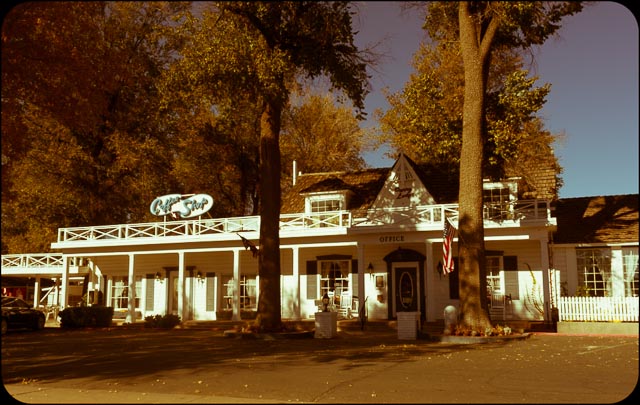
Agriturismo Podere Borgobello in Colle Umberto (PG)

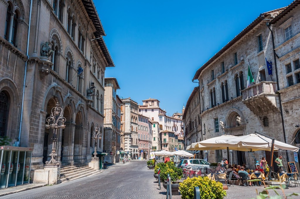
Saturday morning, after a delicious buffet breakfast, we went to Perugia. We were given some parking advice, to go to the lot at Piazza dei Partigiani, since it was still pretty early. From there we easily took the escalators to the top if the ancient town.

Like most Italian cities, Perugia is famous for a particular export, Perugina Chocolate – the company that make those little Baci among many other delicious things. I was hoping there would be a general Chocolate culture, like Modica, Sicily, but it seemed to really just be Perugina. They had a store right in the middle of the historical center where I bought a bar of Fondente Luisa. This is apparently the original dark chocolate recipe the founder started the company with. It’s pretty good!

The escalators of Perugia bring you right into the old ‘Rocca’ or fortress that once upon a time was all that Perugia was. It’s remarkably well preserved and pretty much open to be wondered around. From here you take a second, shorter escalator out to the “modern” historical center. We came up in Largo della Liberta where there happened to be an antiques market happening. There also is the Palazzo della Provincia, the equivalent of a County Capital Building right there and the main, store-lined, street that leads to the main square. The main square is dominated by two large buildings, one on each side. There is the Palazzo dei Priori and the Cathedral of Perugia.


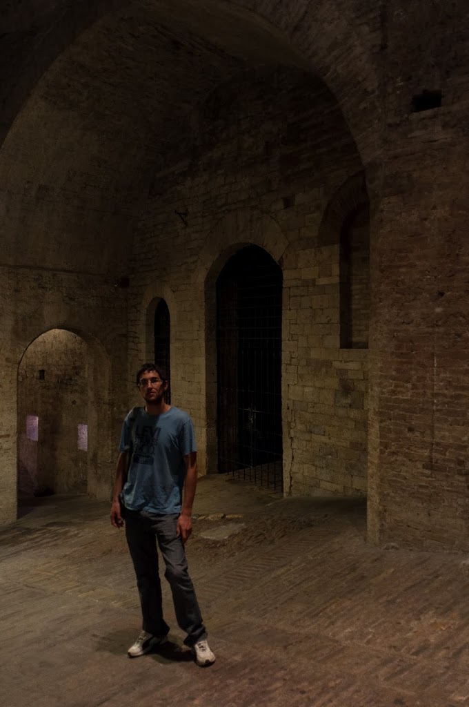
Daniele in Rocca Paolina of Perugia


Me in antiques market in Perugia

As implied by all the escalators, Perugia’s historical center is high up. After we hit the big sites we wondered around a bit and found some beautiful views of the surrounding cities and countryside. There are also some park areas, some small side streets, and just generally lots of charm. I really liked Perugia!


Via Baglioni in Perugia


Panorama of Perugia from above

We started our day early to beat the heat and felt we had seen what we came to see by early afternoon. So we went to another city not to far and generally in the direction of driving back to Rome, Todi. Daniele wanted to go to Todi last weekend and Spoleto won out, which I think was a good call since Spoleto is a bit bigger with a bit more to see. Something I just learned, Todi is a city in Umbria, Toti is the very famous captain on the Roma soccer team, and Todis is a large supermarket brand. In case there is any confusion.

When we got to Todi we had no change for the parking machine, but by some miracle there was some the return change slot, so we used that to pay for two-hours of parking. In that time we climbed up to the top via the main street, stopping for random photos along the way, went around the very top a bit, and came back down. Then we stole some figs from a tree before Daniele pointed out to me they were actually privatly owned (it seemed like a public area). It was my first time eating a fig right off a tree and it was delicious! I saved a few that I made into pizza the next day. Maybe someday I’ll make a food blog. Overall Todi was charming. We were tired, so I don’t know if we missed things, but it felt like we saw it all in two-hours.


Via Giacomo Matteotti in Todi

Then it was back home to Rome. Such a lovely weekend!

Photos from this trip are online here:
https://picasaweb.google.com/111221349198606775660/20120824UmbriaGetaway